Southern Norway and the fjords
This 1,374 km road trip through southern Norway starts at the ferry port in Kristiansand. It follows the coast to the bustling city of Stavanger, near the Lysefjord. The road trip then heads north along Hardangerfjord and Folgefonna National Park to Flåm, the base for exploring Aurlandsfjord, Sognefjord and Nærøyfjord. You follow the north shore of the majestic Sognefjord to charming Brekke, where you drive back south to imposing Bergen and bustling Stavanger.
Highlights along the way include the many fjords, some of the longest and deepest in the world. You will never tire of the spectacular landscapes around the fjords, which are surrounded by mountains, waterfalls and lush green valleys. But southern Norway is more than just fjords. The cities of Kristiansand, Bergen and Stavanger will transport your heart. Along the way, there are numerous historical, cultural or natural gems that will make this trip unforgettable, such as the Preikestolen (a rock formation that is one of the most important sights in Europe), the Folgefonna national park with its imposing glacier, numerous waterfalls, the steepest train ride in the world (Flamsbana), a Viking village, a salmon centre and authentic stave churches. Beach lovers will also get their money's worth, as southern Norway has plenty of lively sandy beaches. This is an unforgettable road trip for young and old alike.
- Perfect travel companion if you want to explore southern Norway and the fjords by motorhome, car or motorbike
- Clearly organised into 6 stages with 42 places of interest, 8 culinary travel tips, 15 hiking routes, 10 cycling routes and more than 100 places to stay (52 campsites and 55 motorhome sites)
- Available as PDF (travel guide 56 pages) in beautiful design, illustrated with inspiring texts and high-quality photography
- Includes interactive map for PC, tablet or smartphone so you have all information at hand on the road
- Includes GPX files so you can download the full route and all cycling and walking routes onto your GPS

Some highlights on this road trip
Kristiansand - Stavanger (235 km)
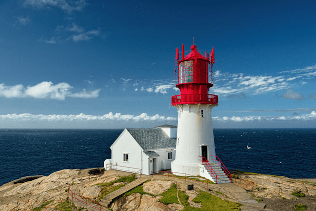
As soon as your motor home, car or motorbike rolls off the ferry, your Norway trip can begin! As we want to feel water all the time on this route, we turn left on the map towards Stavanger. This is the area of sandy beaches, colourful quayside houses and tiny islands. Lindesnes is a nice first stop at Norway's southernmost point with a beautiful lighthouse. In Flekkefjord you cross the first fjord on your journey. Here you can choose two different routes to Stavanger. On the southern route, you pass Egersund, with white wooden houses on the steep cliffs around the fishing port. Gradually you approach Stavanger through the Jaeren Plain. Stavanger is not only the starting point of an impressive fjord system, it is also a pleasant city to visit.
Stavanger - Preikestolen (40 km)
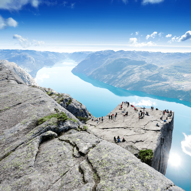
The Lysefjord is breathtakingly beautiful and, together with the Preikestolen (the Pulpit), one of the most photographed places in Norway. The Pulpit is a rock that rises 600m above sea level. An 8 km long spectacular walk starts from the car park. It is one of the best known mountain hiking routes in Norway, so expect about two hours for the ascent. The end point is amazing, especially for those who dare to stand on the rock itself. To avoid crowds, we left at night and were blessed with a beautiful sunrise. An extra recommendation for those who have the time and inclination: drive on to Månafossen, with 92m the largest waterfall in the region. You can make nice, short hikes there.
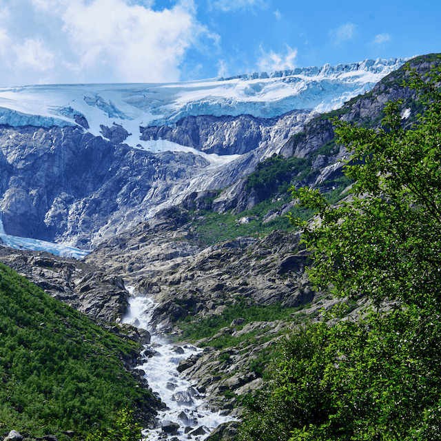
Preikestolen - Folgefonna National Park (200 km)
If you are interested in the world of salmon and trout, we recommend a stop in Sand (Suldal municipality). Here, you are at the mouth of the Suldalslagen salmon river and can watch the fish swimming up the stairs at the Sandsfoss waterfall. Next stop is Langfoss, one of the entrances to Folgefonna National Park. The park is home to Norway's third largest glacier, covers approximately 545 km² and is a protected landscape. Lovers of fauna and flora will find their heart's content here. During our visit in the high season, we hardly saw any people, which was a relief after the crowds around Preikestolen.
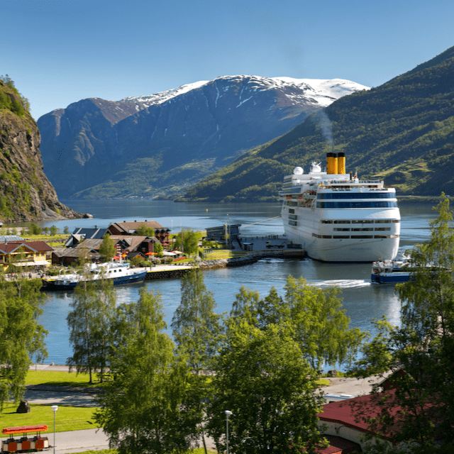
Folgefonna Nationaal Park - Flåm (154 km)
On the road to Flåm and the Sognefjord, after the Folgefonna National Park, you pass the Sorfjord, a long arm of the Hardangerfjord. It was amazing to discover that this part of the route is a fruit region, there are more than 200,000 fruit trees on the slopes along the fjord! On the right-hand side of this route is Hardangervidda, Europe's largest plateau, known for its hut-to-hut hikers. Due to time constraints, we have left it - literally - to the right. The final destination of this part of the route is Flåm, a tiny village on the Aurlandsfjord. From the campsite you can see the cruise ships mooring and all around are steep mountains, narrow valleys and roaring waterfalls. The train from Flåm is the best way to see this natural beauty, and the train ride has been named the most impressive train ride in the world.